WATERMELON CRAWL
  • Home
  • Trails
  • Register
  • Discounts
  • Sponsors
  • Contact

TRAILS

Picture
EXPERT

Trails rated expert require high levels of skill and experience. 
Very steep or narrow trails, sharp alignments, rough or loose tread surfaces, and substantial obstacles.
​
Picture
ADVANCED
Trails rated advanced are intended for OHV enthusiasts with well-developed skills seeking a reasonably challenging trail ride.
Riders subjected to higher degree of risk and exposure.
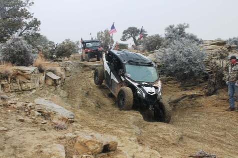
Picture
INTERMEDIATE 
Trails rated Intermediate are suitable for the majority of intermediate riders.
These trails are narrower with steeper hills and switchbacks and some moderate obstacles.
Picture
BEGINNER
Trails rated beginner are highly-developed class of trails (almost road like) with no steep hills and few obstacles.
Intended for novice riders who have mastered the basic skills necessary for safe operation on well-developed trails. 

Stay on the designated routes


our unique trails

Picture
behind_the_reef.kmz
File Size: 14 kb
File Type: kmz
Download File

Behind the Reef      Rating: Intermediate
Trailer to trail head 
​48 Miles -- Approximately 6 hours
Sponsored by Backroad Discovery Utah
Trailer to the staging area just north of Goblin Valley State Park and take off on a scenic loop along the backside of the San Rafael Reef.  This is a beautiful ride.
​

Behind the Reef Trail File

  staging location 42 miles from Green River -- Coordinates 38.65656 -110.66103


Picture
Buckmaster         Rating: Beginner
​Ride directly from town

​47 miles  --  Approximately 6 hours
Sponsored by Outlaw Trails Garage
Ride directly from the Shady Acres Gas Station in Green River.  This ride is fun for the whole family.  Looping west of town towards the San Rafael Reef you will drop into Cottonwood Wash just north of the San Rafael River and head north to Smith's Cabin.

buckmaster_22.kmz
File Size: 15 kb
File Type: kmz
Download File

Buckmaster Trail file


Picture
 Eagle Canyon       Rating: Advanced
 Trailer to trail head
​ 39 Miles -- Approximately 5 hours
 Sponsored by GT Outfitters

 This ride stops at places like Swasey's Cabin and The   IceBox. Take your chance to get one of the most iconic   photos in the state under the Eagle Canyon bridges.


eagle_canyon22.kmz
File Size: 9 kb
File Type: kmz
Download File

Eagle canyon trail file

staging loaction 31 Miles from Green River  --  COORDINATES 38.88275 -110.65965


Picture
Dry Lakes               Rating: Intermediate
Ride directly from town
​71 Miles -- Approximately 7 hours
​Sponsored by Sandy Big O Tires
Ride directly from the Shady Acres Gas Station in Green River.  A local favorite loop south of Green River with stops at 2 cold water geysers. 


dry_lakes_22.kmz
File Size: 20 kb
File Type: kmz
Download File

Dry lakes trail file


Picture
The Devil's Racetrack            Rating:Expert
​Trailer to trail head
​40 Miles  --  Approximately 7 hours
Sponsored by Full Throttle Powersports
Trailer to exit 131 on I-70.  This more difficult trail is one of the most recognized by name. If you're looking for some challenging areas, this is your trail.


devils_racetrack_22.kmz
File Size: 27 kb
File Type: kmz
Download File

devil's racetrack trail file

Staging location 31 Miles from Green River -- Coordinates 38.88275 -110.65965


Picture
Butterfly               Rating: Intermediate
Ride directly from town

46 Miles --  Approximately 5 hours
Sponsored by City of Green River
Ride directly from the Shady Acres Gas Station in Green River.  This fun loop south of town shows off some of the wide open spaces that make Green River an off road paradise. 

butterfly22.kmz
File Size: 24 kb
File Type: kmz
Download File

butterfly trail file


Picture
Lost Springs            Rating: Advanced
Trailer to trail head
​39 Miles  --  Approximately 6 hours
Sponsored by GT Outfitters
Trailer up Highway 6 north of town and take off on this awesome trail. A great ride to explore some amazing country.

lost_springs22.kmz
File Size: 7 kb
File Type: kmz
Download File

Lost springs trail file

Staging location 12 miles from Green river -- Coordinates 39.10231, -110.32501

Proudly powered by Weebly
  • Home
  • Trails
  • Register
  • Discounts
  • Sponsors
  • Contact